Day 27. April 28. On to Charleston. 31.9nm. Total 735

 We spent April 25-27 in Bohicket Marina on John’s Island with family, getting Bill’s dental work completed, shopping and eating wonderful Southern food in friendly Southern hospitality.  It was hard to leave. But onward we must go!  What made it a bit easier was that our son, Kyle, joined us for the cruise!


We left the marina and traveled on the winding Wadmalaw River past Wadmalaw and John’s Island.  The scenery was a mixture of developed areas with large areas of natural growth and tidal marsh.

The Wadmalaw River met the Stono River and we continued past the mainland which is largely developed  with homes and docks and the tidal marsh off the northern edge of John’s Island.  We even enjoyed watching a few rounds of golf as two greens in one development were right on the river.


Also enjoyed the picnic lunch that my sister, Kathy provided as we traveled to Charleston.  Was delicious just like everything she cooks!


Next we had to tackle the strong currents in Elliot Cut.  Bill negotiated the currents well and we made it through safely.  As we left the cut, we entered Charleston Harbor and the skyline of Charleston came into view.  


We pulled into the Charleston City Marina, tied up and settled in.

Our plan is to use the marina shuttle and do a self guided historic walking tour with Kyle, then do an early dinner before Kyle needs to get to the airport and head home. 

We walked the French Quarter of Charleston-named for the French merchants that lived in this area.  The French Quarter was part of the original walled city settled in 1680.

Historical sites in the French Quarter-

Pink House Tavern, one of the oldest buildings, erected in 1712


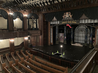
Dock Street Theatre, site of the first theatrical productions in the United States


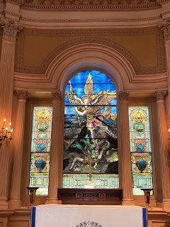
St Michaels Church, the oldest church building, completed in 1761.


St Philips Episcopal Church, the first congregation in Charleston, dating from 1681.  We walked the graveyard which had graves dating back to the late 1600’s and had many Revolutionary War grave sites.


Charleston County Courthouse was originally used as an administration building for the British and served also as the State Capitol Building. The current structure dates back to 1788 when the original building was destroyed by fire.


City Market Hall was a public market originally built in 1788 to house fish, meat and vegetables vendors.  In 1807, stalls rented for 25 cents.  In 1841, the current Market Hall was built.  The market was famous for vendors weaving sweet grass baskets.  Today the market is filled with local foods, and arts and crafts.


Powder Magazine, dated 1713, was originally a British armory, later it stored ammunition in the Revolutionary War.  We ended our walk at the newer Waterfont Park and walking past the houses dubbed Rainbow Row.


Was sad to see Kyle go, we thoroughly enjoyed his company.


Will end with some pictures of old homes we walked past. Cobblestone streets and the last shot is the oldest brick structure in Charleston 


Above is a map the Charleston and the surrounding areas and islands.

Popular posts from this blog

Side trip to the Bahamas- Preparations

 As we prepare for our Bahamian Adventure, we are making lists upon lists of things to do and provisions to buy for our upcoming trip to the Bahamas. Bill has spent much time readying the  boat for the cruise, checking engines, batteries and all the systems on the boat - electrical, plumbing, navigation, refrigeration and air conditioning.  Sure kept Bill busy!!! We took the boat out to check all the systems and to get fuel.  We had to re-remember all the navigation and auto pilot workings and surprisingly we did remember!! We have spent the last two days loading the boat with provisions- water, food, tools, clothes, toiletries and cleaning supplies, and our pantry and cabinets are full.   We are sitting a bit heavier in the water now that we are fully loaded.  Also Bill has finally gotten his TO DO list down to the few remaining items so he sees the light at the end of the tunnel!! We have researched the charts and guide books and have a tentative pla...

Day 24-25 April 15-16 On to Hopetown and Lay day in Hopetown. Miles 12.6. Total 460.6

Day 24 We had a change of plans.  Our friends who we met cruising the Loop, Trisha and Mike, are traveling north through the Bahamas and are close, so we will join then in Hope Town.   We will then back track a bit to visit Man-o-War Cay and Marsh Harbor after visiting with them. It is a bright sunny day with light winds as we weigh anchor to leave Great Guana. There is lots of freight and commercial traffic today- tugs and barges, large freighters and flat bed delivery boats.  It takes all these to handle the shipping needs and construction on the islands. We trip today took along the north east side of Great Guana and then past Scotland Cay, which is all privately owned.  Next we passed Fowl Cay which is a nature preserve known for its diving.  Following Fowl Cay is Man-o-War Channel with its deep water access to the Atlantic and Man-o-War Cay, known for its ship building and maintenance. Sorry, pictures of the passes and islands did not turn out too well...

On to Allan's-Pensacola Cay. Day 12. April 3. Mile 35.2. Total mile

  Day 12 We left our anchorage at sunrise to head out of Great Sale Cay Harbor. Turning west and then north, we will cruise around Great Sale Cay toward Abaco's barrier islands, eventually reaching the eastern edge of the Little Bahama Bank today. As we turn Northeast, we get some spray.  Crustacean is quite salty now!   Winds are out of the east 10-15 knots with waves at one foot. We cruise past Little Sale Cay we see a steady stream of sailboats going both east and west.  I counted 15 total.  Nice wind for sailing. Halfway through our trip, you begin to see the outer barrier islands on the horizon to the north.  Five miles later you can see Little Abaco Island to our south.  Here is a chart of the area we traveled from Great Sale to Allan's-Pensacola Cay today. The further we travel east, the Little Bahama Bank narrows,  The winds pick up and seas run 1-2 feet. Crustacean got even saltier! As we approached Allan's-Pensacola the wind and sea...