
June 24. Day 83. On to Troy NY. 30 Nm. Total 1810. Also on to Waterford NY. Day 84

 It’s a beautiful sunny day, leaving Hudson, NY.  The river is flat calm and it’s two to four knot current is pushing us along as we head north.  


This section of the river has islands with channels behind them-similar to oxbows, a scattering of small towns- Coxsackie, Stuyvesant, New Baltimore; and large farms ( along the west shore).


Surprisingly, we had quite a bit of barge and ship traffic along the way.


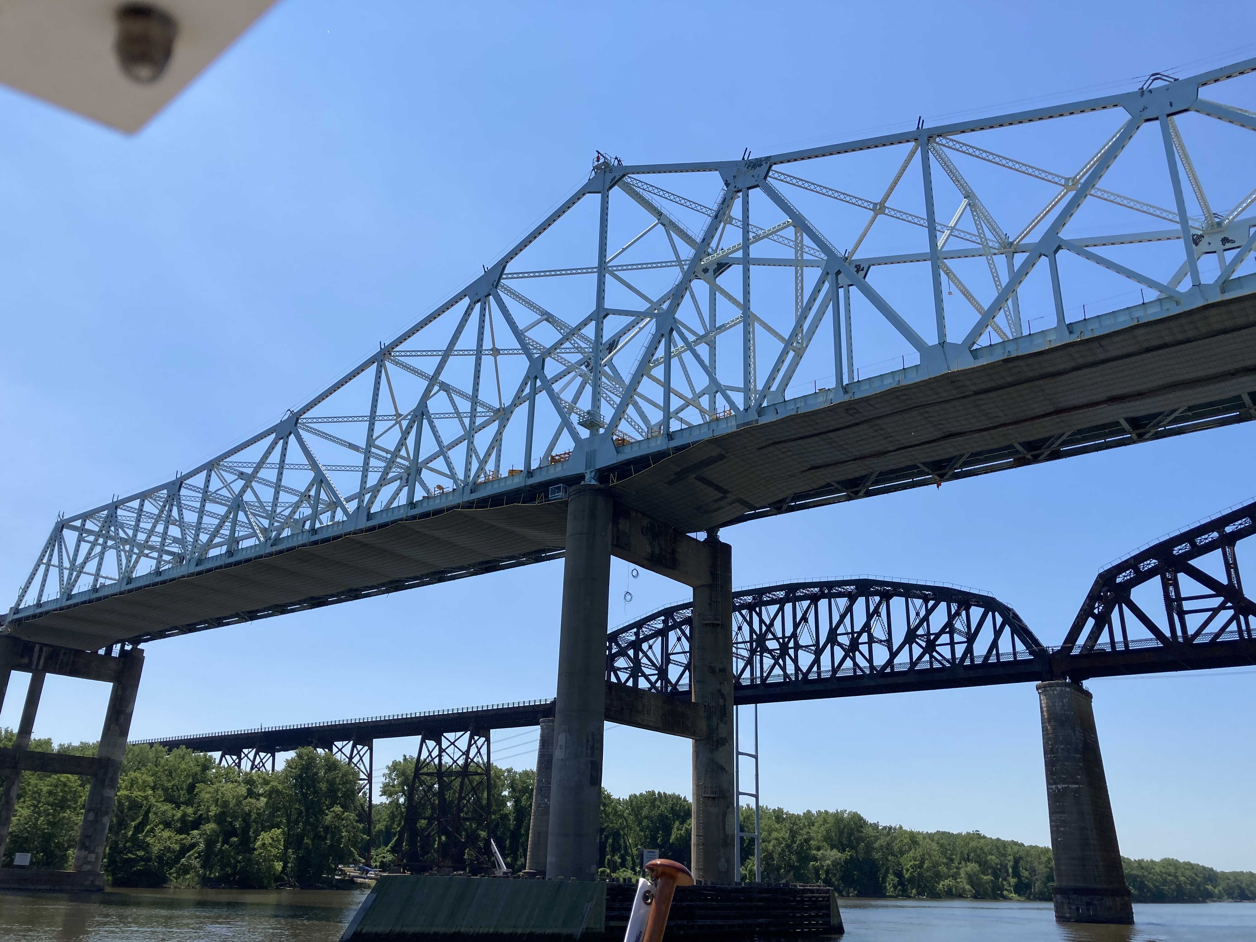
We traveled under the Castleton on Hudson bridge an the town of Castleton on the eastern shore.


After a few miles north of the bridge, the river turns and you can see the first of the buildings of Albany, NY.  We stopped in Albany at their free dock so we could walk the city.


Walking through Troy, we admired the older architecture dating from the late 1800’s to the early 1900’s..  we especially enjoyed the Delaware Hudson Railroad Building built 1814-1918, several churches, and the State Capitol Building.


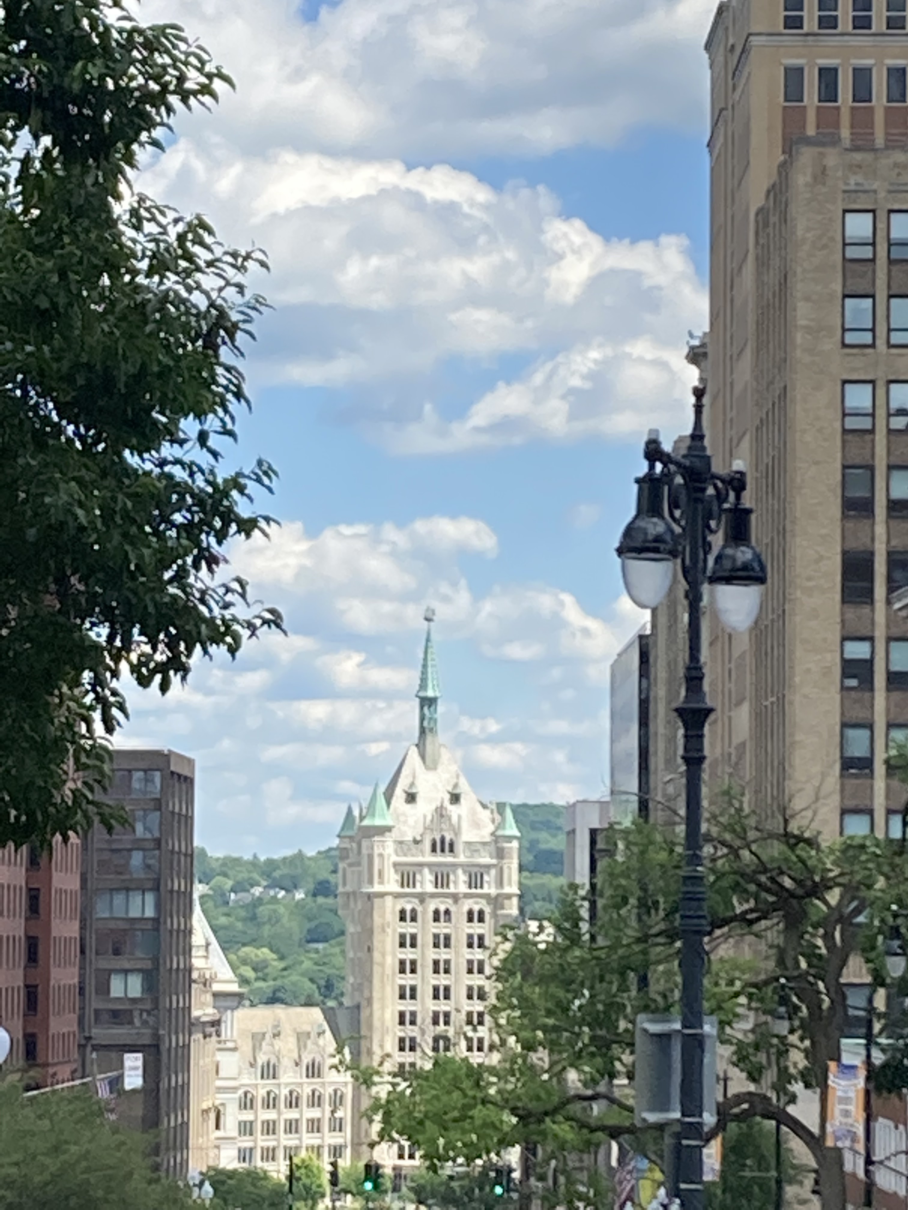
After lunch, we continued our walk to the Nelson Rockefeller Empire Plaza built in 1965 and the Corning Building.  


We rode the elevator to the 42nd floor observation deck which had great views of the Hudson River Valley and Albany.


We returned to the boat, cast off our lines and headed north to the City of Troy to tie up to the city dock.

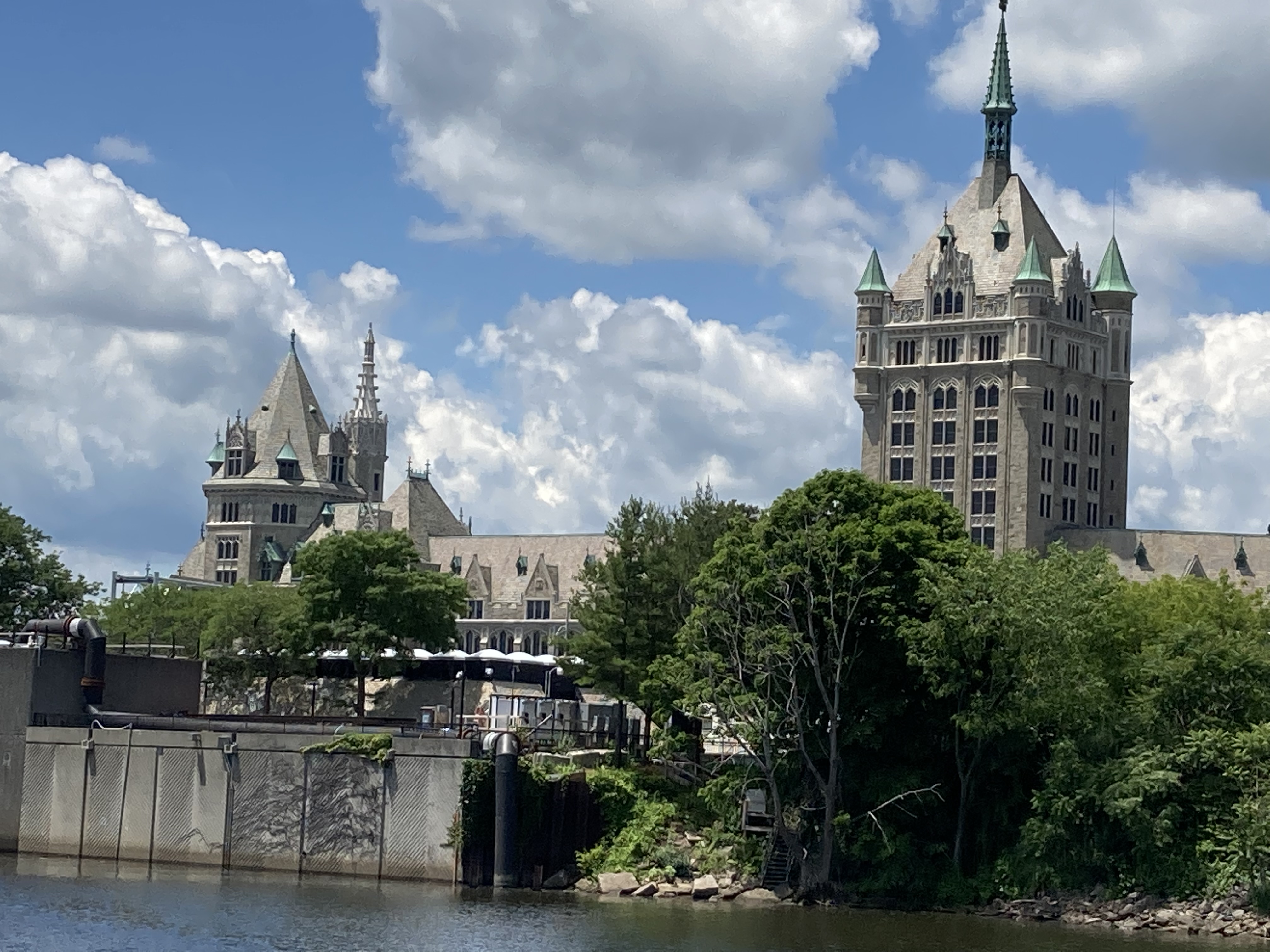
Along the way, we sited a castle amongst the many old warehouses on the Hudson River.  With some research we found it was called Shoddy Fortress- constructed in the early 1900’s.  This brick warehouse castle was built by the United Waste Manufacturing Company and it served as a warehouse for cotton and wool shoddy.


In researching the Shoddy Castle,  I came across  another castle in Troy which was built in 1896 by John Welles Paine, financier and lawyer as a personal residence- the Grandest in Troy.  The home boasts, stained glass windows, frescoes, mosaics, 16 fireplaces, and mahogany woodwork and trim.  Today the castle is owned by the alumni of Alpha Tau Chapter of Pi Kappa Phi at the campus of Rensselaer Polytechnical Institute.  For over 70 years, the brothers have maintained and preserved this building.  Thought a few of our readers might be interested in that!! We found this home as we walked around the city this evening!


The city of Troy was one of the wealthiest cities in America at the turn of the century and into the 1900’s.  Troy is known for its textile industry (especially shirts and collars), iron production, shipping, and the Rensselaer School founded in 1824 and which is now the famous Rensselaer Polytechnical Institute.


Day 84  June 25     on to Waterford    3.3 Nm         Total 1813

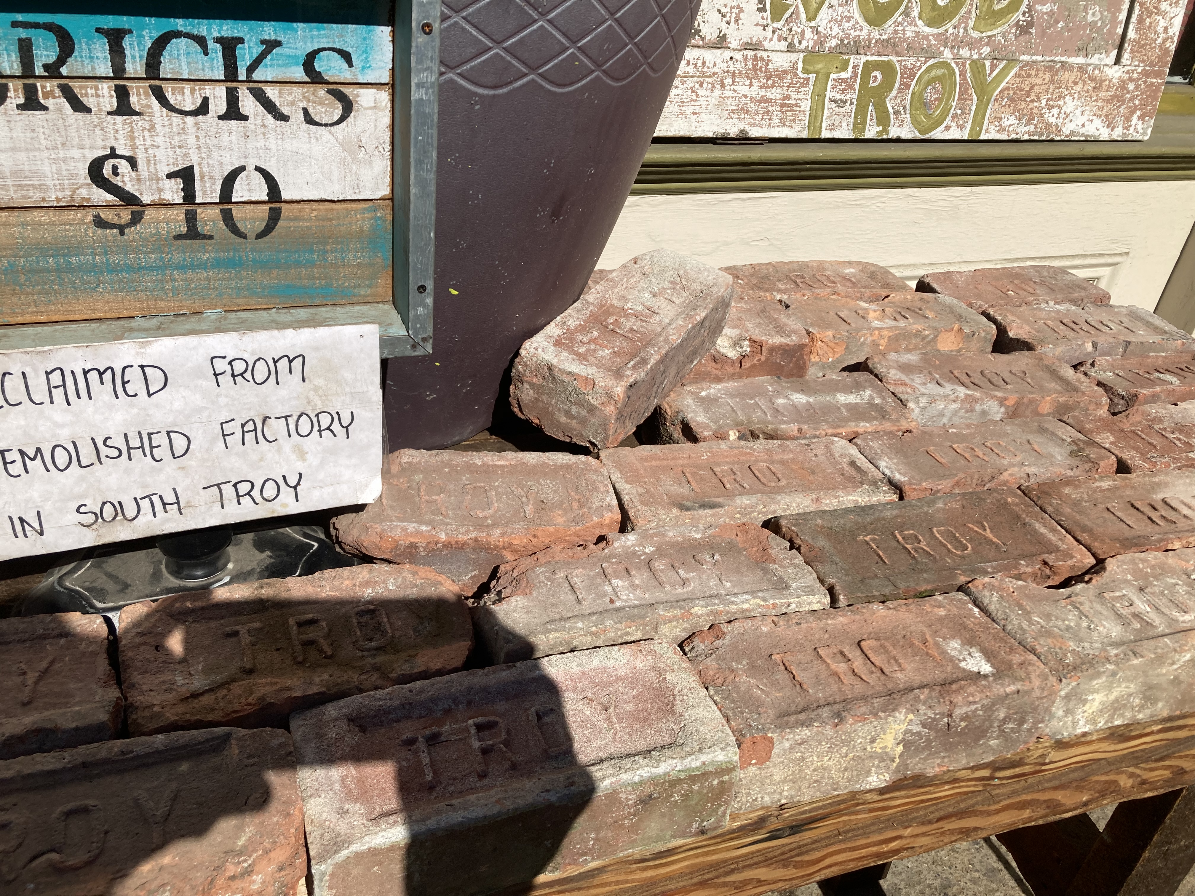
We got up early so we could go to the farmers market in downtown Troy.  They had a variety of vendors from spices to fresh meat and veggies, to breads and pastries, to honey and jams.  We went for some fresh veggies and fruit, but Bill could not resist the baked goods and he had to have himself a Troy brick.


Returning to the boat, we stowed our goodies and cast off.  Today is a short day travel wise and we will go thru our first lock just north of downtown Troy.  We hailed the lock master and he informed us there would be a twenty minute wait as he was locking thru a southbound vessel, so we tied up to the lock wall to wait.


When we got the green light to enter the lock, we came in behind two other boats and looped our line around the cable for the 8foot rise in water in the Hudson.   After the lock the river is narrower here with homes and condos on both shores.  We are still in the city of Troy until we go under the bridge one mile north of the lock and turn into the Mohawk River- the beginning of the Erie Canal.  We tied to the linear dock and hooked up to electric and water.  Since dockage is free we only paid to use the electric.  Plan to stay two nights.   


We spent most of the morning helping others get tied up to the dock and sharing Looper stories.  Our friends on Pivot joined the dock crowd later in the afternoon.  After lunch, we walked across the bridge over the Hudson River to get a few groceries that were not at the farmers market.  

The local grocery store allows boaters to take the shopping cart back to the docks and they come by later to pick up the cart.  What a nice service!

After dinner we headed out to walk the trail that follows the Erie Canal. We walked to Lock 2 and saw the spillway and lock area of the original 40 foot canal.


These last two pictures are of the lock currently used on the Erie Canal.

Later this evening, Jen and Elliot from Pivot came over and taught us a new card game, called “Shithead”.
We played three games and Eliot lost once and Bill lost twice. So he is the official “Shithead” til we play next time!


Popular posts from this blog

June 4-5. Day 63-64. On to Cape May New Jersey. 53.4nm. Total 1534 miles.

 Left Delaware City at 5:35am to be able to take advantage of the strong currents going with us while traversing Delaware River and Delaware Bay. The Delaware River goes south about 15 miles and flows into the Delaware Bay. As we travel south, New Jersey is to the east and Delaware is to our west. We are traveling just outside the shipping channel and are really moving at 10.9 knots.  That is three knots faster than we normally travel, as the outgoing tides are pushing us along.  Nice to have Mother Nature helps us save on fuel.  The Delaware River is about 8 miles wide so there is plenty of room for the freighters and the pleasure boats.  So far, we have not encountered any commercial traffic, but there is a large freighter behind us that will eventually pass us as they travel at 14 knots. The Delaware Bay proper varies from 23-29 miles wide and 26 miles long.  There are five lighthouses on the Delaware marking the shipping channel.  We went by Ship J...

Reflections on the Bahamas

Reflections on the Bahamas Over the past 10 weeks, we have traveled through Abaco,  Eleuthera and Exuma Islands and enjoyed the hospitality of the Bahamian people.  We have learned all about the islands, its unique geography - limestone, caves, blue holes and chalk cliffs; and colorful history-pirates and rum running, salt ponds and cotton plantations, boat building and wrecking/salvage.  Traveling over 1300 miles through narrow cuts and wide bays to vast depths of ocean, we negotiated the islands and found safe harbors, calm coves for anchoring, bays filled with moorings and marinas large and small.  This trip required us to pay close attention to the weather, the tides and currents as we traveled between and through the islands. The Bahamian people are warm and friendly, willing to give us rides, advice and directions, as well as some secret recipes!!  We enjoyed hiking trails, walking the beaches, snorkeling the coral rocks and reefs, discovering ruins and ol...

Day 64-65. May 25-26. On to Peck Lake, Jupiter, FL and then on to Indiantown/ Okeechobee Waterway. Miles 63.5/ 29.1 Total Miles 1122.1/1142.0

  Day 64 We started early to get ahead of the holiday boat traffic. Weighing anchor at Lake Sylvia in Fort Lauderdale, we traveled on the Intracoastal Waterway past the iconic Pier 66 Tower and Bahia Mar Marina.  We then turned north and passed the older sections of the city - Las Olas( older homes), Galt Ocean Mile (one mile of condominiums on the beach), and the famous miles of beaches on the Atlantic.  I used to live here in the early 70's and the biggest change I see is the older smaller homes on the water are being replaced with larger versions and a few more condo towers have been built. As we go further north towards Commercial Blvd, North Fort Lauderdale, and Pompano Beach and its Lighthouse at the cut, there is less reconstruction. The next town we traveled through was Boca Raton with its Spanish architecture, Camino Real and its  landmark tower. The sand bar at the cut was just beginning to fill up  with Memorial Day revelers as we went by. Next were t...