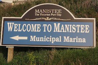
Day 98. 2nd year. August 27. On to Manistee. Miles 25 Total miles. 3910.

 We weighed anchor on a sunny 50 degree morning.  So we put on our sweatshirts and drove from below as we left Frankfort.

Going through Frankfort’s channel and breakwater we encountered a few intrepid fisherman and further along as we cleared the breakwater there must have been over a hundred fishing boats.  Almost like playing bumper cars, but with boats.  Had to negotiate a path between them as the fishing boats were all trolling fishing lines behind them.  We were still seeing fishermen 4 miles south of Frankfort.  These guys sure take their fishing tournaments seriously!


The shoreline that we pass heading south are still sand dunes bluffs some as tall as 200 feet.


As we travel, we pass the small town of Arcadia and Portage Lake, each situated on an inland lake which is connected to Lake Michigan by a dredged channel.  Interesting to note that the dredged channels were originally small rivers connecting the inland lakes to Lake Michigan.

As we passed the dunes surrounding Portage Lake we could see the lighthouse marking the entrance to Manistee- our destination today.  (The name Manistee is Ojibwa for river with islands at its mouth.)

History of Manistee

The town was first settled by one family in 1841, who built a saw mill and made a living off lumber and farming.   By 1849, more settlers arrived and by 1885 the town boasted 40 saw mills.  At that time Manistee had city provided water, sewer, fire protection, street lights and parks.  Pretty fancy for a city of that era.  At that time Manistee claimed to have more millionaires per capita than any other city in the US. Today the city is known for its paper packaging production, metal works, salt harvesting, fruit production, fishing and tourism.

As we entered the channel into Manistee, we past it's beaches, dunes and lakefront park. Laterin the channel we passed homes up on the southern bluff, and further in marinas catering to the charter business,  We tied up at the Municipal Marina and settled in.


Soon after we headed to town for lunch at a local pub, then continued walking down River Street, the old downtown which has been preserved as it was in 1880-1910.  The town has done a wonderful job of preserving the past.  


We stopped in a few art and antique stores and the continued walking to Lake Manistee, where we passed an old train station under preservation and an old iron foundry.

On Manistee Lake we could see industrial areas which we later identified as plants producing  paper products, metal fabrication and salt harvesting.  Steamers used to carry Manistee’s products, as well as people, to Chicago and Milwaukee.  Later freighters took up the load.  These shots are of pictures of the freighters that plied these waters.


We returned to the boat by walking through a older residential neighborhood with homes and churches dating back to 1880-1896, when the town of Manistee was in its heyday


and then continued walking back to the boat along the Riverwalk. 

Having walked quite a bit, we rested our tired feet, so we could tackle the rest of the Riverwalk later today.

Having rested a bit, we took off to walk Riverwalk to the beach on Lake Michigan.  The Riverwalk is a boardwalk all along the  Manistee River which has placards that tell the history of Manistee and the people who settled here. So we walked and read about fishing, sawmills, salvage and boat building,  steamer lines transportation,  as well as,  the boat captains, doctors and lawyers, teachers, newspapermen, civic leaders, fishermen and lumbermen who contributed to the development of Manistee.  Was a nice 3-4 mile walk.


We took a side trip to walk on the beach and its dunes.


Bill walked out the concrete pier to get a picture of the lighthouse.


We then turned our tired feet around and headed back to the boat.

Popular posts from this blog

Reflections on the Great Loop -

 Over the 5 and half months last year and the almost 7 months this year for a total of 351 days, we travelled 6348 miles, through two countries 19 states, traversed over 200 locks to find large cities, small towns, farmland, and vast natural waterways and bays. Our route took us through sites of the Revolutionary War, War of 1812 and Civil War, as well as the history of  how America grew along her waterways.  Beginning with canoes, rafts and barges people and goods moved through these waters.  The sailing sloops and steamships changed these rivers, requiring locks and canals to be built to facilitate travel and commerce.   Today it is amazing how much commerce moves through these waters.   We developed a healthy respect for the freighter and tow captains and lock masters and harbor masters that keep the system working. We have lasting impressions of early morning sunrises, beautiful sunsets, and moonlit bays,  the hospitality in all the towns we visited, the vast undeveloped shorelines

Day 194-195. 2nd year. December 3. On to Redington/Clearwater and then to Home. Miles 15 Total MIles 6021

 Slept in again. Was nice to finally catch up on our sleep.  Found our morning a bit foggy but promises to be a sunny day once it burns off. One of the boaters attracted a female manatee and her baby with his hose, so we walked over to the next dock to enjoy the show.  Manatee are often found in shallow areas this time of year as they like the warm water.  They also will take advantage  of access to freshwater, especially if a hose is left hanging over the side of a boat. Bill also took some drone shots of Caladesi State Park. We did one last beach walk before we left today, turning north to explore that part of the island.  Found a few turbans, an olive, 2 small horse conch and a whelk for our shell treasures today.  Sea fog started to come in off the Gulf so we turned around and headed back to the boat. We left later in the day as we had to be close to a high tide to get out the channel at Caladesi.  A local boater offered to lead the way to a cut that provides more water so we took

April 2 2022. We cast off our lines!

 Day 1. April 2 We cast off our lines at 9:00am on out Great Loop adventure.  Our friends, Phil and Aggie helped record our departure.   The weather was overcast as we traveled out our canal and into Tampa Bay.  As we approached the Skyway bridge a dolphin twice leaped completely out of the water, playing in our bow wake.  An omen of good fortune for our adventure! As we ended our Tampa Bay crossing, the sun began to peek out and as we traversed past Longboat Key/Bradenton and entered Sarasota we had ourselves a sunny day.  We traveled 34.4 nautical miles in four hours and anchored behind Otter Key, a mangrove Island near Lido Key in Sarasota.  There we joined another boat from St Petersburg, FL.  The owners were for many years sailors from the Caribbean down to Panama.  What adventures they shared! The anchorage sports lots of manatees, dolphin and of course, the osprey who lords over Otter Key. Once settled properly, we took a nap,  Will spend the rest of our day with a glass of wine