
Day 37. April 28. On to Spanish Wells, Eleuthera. MIles 61.9 Total Miles. 562.1

 Day 37

After pondering the weather, we decided to go out of the pass and see the sea conditions.  We battened down all loose items, had breakfast, and packed lunch. I readied the boat while Bill took the drone up  for some last minute shots of Little Harbor.  

These shots are of the harbor.

This shot is looking south back onto Great Abaco Island. And the ones below this are of the entrance to the harbor.


This last shot is of the Bight of Robinson and looking north

Fired up the engines and loosed the mooring lines and left Little Harbor, starting our journey south to Eleuthera.  The swells were 3.5 feet at about 6.8 seconds.  Winds were 8-10 knots.  Was a bit rolly, but we were taking the seas on our quarter bow so it was not bad at all.  Decided to make a go of it!!  The swells were supposed to diminish as the day progressed and the periods between waves lengthen.

Here is Bill with his wide leg stance to steady himself from the action of the seas on the boat.

We watched as Great Abaco Island gradually disappeared as we headed 185 degrees to Eleuthera.  We had a number of sport fishing boats out with us first thing, trolling for a catch. In our first hour we ran depths of 9840 feet!

In the second hour, waves went down to 2.5-3 feet and the water is such a deep blue.  Found depths up to 13,123 feet.  Now have a few sailing vessels out to join us this morning.  Afraid not many shots today, as everything is so far away.

Our third hour, we finally passed the SV Cheyenne, which we had been following since we left the cut.  Waves and sea conditions are the same.

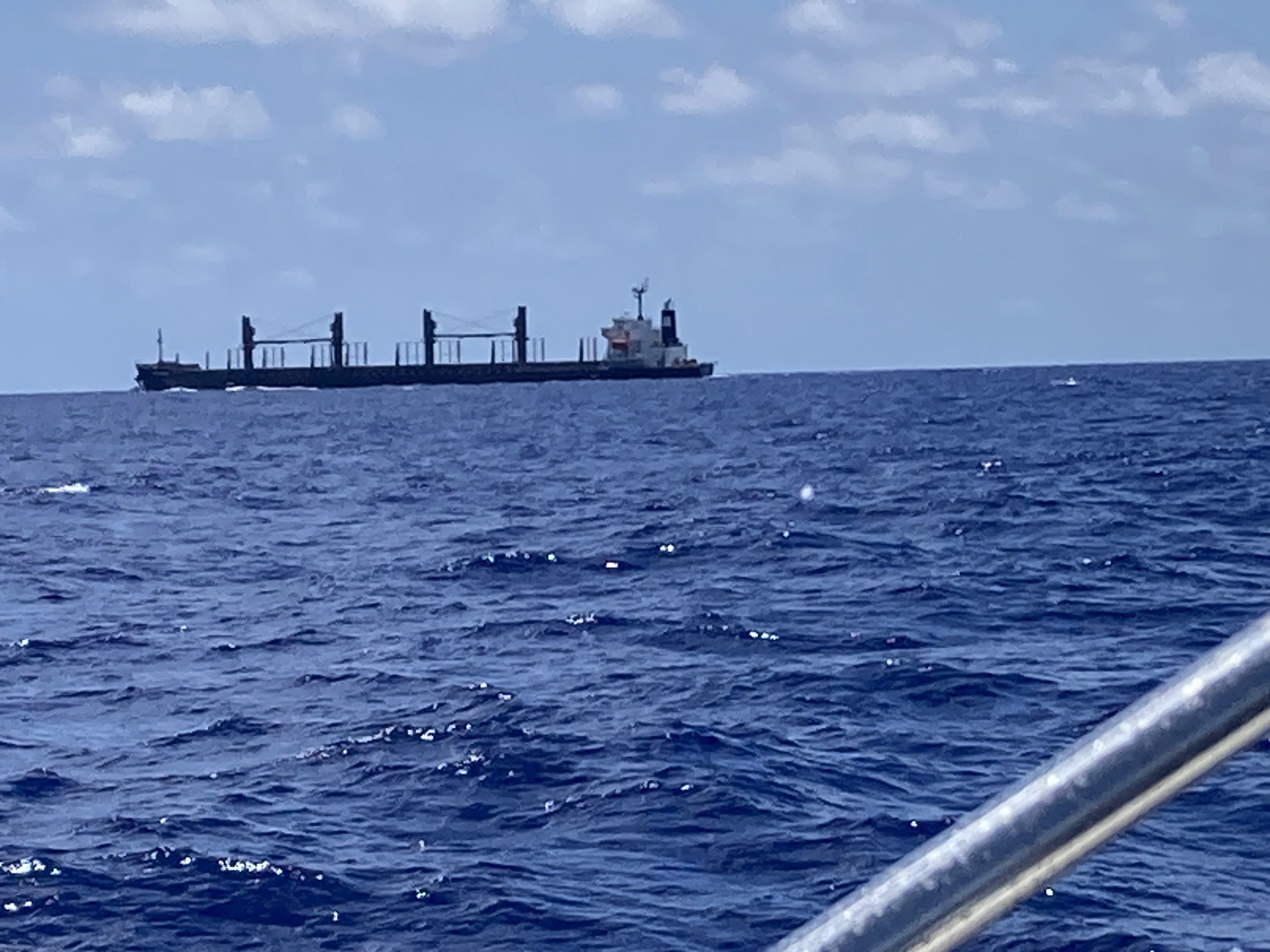
In the fourth hour, we traveled past Great Abaco Island's last community to the south, Hole in the Wall,  and then entered Providence Channel.  It is still over 13000 feet deep and the swells have settled to 2-2.5 feet.  Also came upon this 180 meter freighter.

In the fifth hour, we are traveled in the last bit of Providence Channel and we can see the outline of Northern Eleuthera.  Land Ho!!  Water depths begin to decrease out of the thousands.

In our last hour of travel today, we got behind he eastern islands off Eleuthera and get protection from the east winds and waves.  Sea conditions are quite calm.  We travel past the outer Egg Island's reef and Egg Island itself.  We opted to travel through the Little Egg Island channel to turn north into the bay formed by these out islands.  


We cruised past Royal Island and its harbor that can shelter smaller boats.


To come behind Russel Island and anchor with about 12 other sailing boats.  Here is our anchorage.


Was nice to turn off the engines and take a deep breath.  Was a long day and we celebrated by taking a nap!

Spent the evening reviewing all there is to see on Eleuthera, so we could explore starting tomorrow.


Popular posts from this blog

June 4-5. Day 63-64. On to Cape May New Jersey. 53.4nm. Total 1534 miles.

 Left Delaware City at 5:35am to be able to take advantage of the strong currents going with us while traversing Delaware River and Delaware Bay. The Delaware River goes south about 15 miles and flows into the Delaware Bay. As we travel south, New Jersey is to the east and Delaware is to our west. We are traveling just outside the shipping channel and are really moving at 10.9 knots.  That is three knots faster than we normally travel, as the outgoing tides are pushing us along.  Nice to have Mother Nature helps us save on fuel.  The Delaware River is about 8 miles wide so there is plenty of room for the freighters and the pleasure boats.  So far, we have not encountered any commercial traffic, but there is a large freighter behind us that will eventually pass us as they travel at 14 knots. The Delaware Bay proper varies from 23-29 miles wide and 26 miles long.  There are five lighthouses on the Delaware marking the shipping channel.  We went by Ship J...

Reflections on the Bahamas

Reflections on the Bahamas Over the past 10 weeks, we have traveled through Abaco,  Eleuthera and Exuma Islands and enjoyed the hospitality of the Bahamian people.  We have learned all about the islands, its unique geography - limestone, caves, blue holes and chalk cliffs; and colorful history-pirates and rum running, salt ponds and cotton plantations, boat building and wrecking/salvage.  Traveling over 1300 miles through narrow cuts and wide bays to vast depths of ocean, we negotiated the islands and found safe harbors, calm coves for anchoring, bays filled with moorings and marinas large and small.  This trip required us to pay close attention to the weather, the tides and currents as we traveled between and through the islands. The Bahamian people are warm and friendly, willing to give us rides, advice and directions, as well as some secret recipes!!  We enjoyed hiking trails, walking the beaches, snorkeling the coral rocks and reefs, discovering ruins and ol...

Day 64-65. May 25-26. On to Peck Lake, Jupiter, FL and then on to Indiantown/ Okeechobee Waterway. Miles 63.5/ 29.1 Total Miles 1122.1/1142.0

  Day 64 We started early to get ahead of the holiday boat traffic. Weighing anchor at Lake Sylvia in Fort Lauderdale, we traveled on the Intracoastal Waterway past the iconic Pier 66 Tower and Bahia Mar Marina.  We then turned north and passed the older sections of the city - Las Olas( older homes), Galt Ocean Mile (one mile of condominiums on the beach), and the famous miles of beaches on the Atlantic.  I used to live here in the early 70's and the biggest change I see is the older smaller homes on the water are being replaced with larger versions and a few more condo towers have been built. As we go further north towards Commercial Blvd, North Fort Lauderdale, and Pompano Beach and its Lighthouse at the cut, there is less reconstruction. The next town we traveled through was Boca Raton with its Spanish architecture, Camino Real and its  landmark tower. The sand bar at the cut was just beginning to fill up  with Memorial Day revelers as we went by. Next were t...